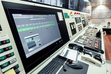


Navigating safely and efficiently relies on accurate, up-to-date data, but current electronic charts (based on the S-57 standard) are limited in how they handle complex, real-time information. The S-100 data framework, developed by the International Hydrographic Office (IHO), is designed to overcome these limitations, allowing mariners to access multiple, high-detail data layers directly within their ECDIS. This means better route planning, real-time environmental updates, and a clearer picture of navigational hazards — improving both safety and operational efficiency.
What is the S-100 framework?
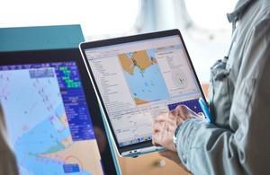
The S-100 framework is the next-generation hydrographic data standard, replacing the long-standing S-57 format. Unlike S-57, which has fixed and limited data types, S-100 supports a much wider range of navigational data, including high-resolution seafloor mapping, real-time tidal streams, surface currents, and dynamic navigational warnings. This means that instead of relying on separate sources for critical information, mariners will be able to overlay these datasets directly within an S-100-compatible ECDIS, making navigation safer and more efficient.

How S-100 will improve navigation for mariners
Compared to today’s S-57 charts, S-100 introduces several key advantages:
- More detailed seafloor mapping — Improved bathymetric data means safer navigation in shallow waters. This includes combining bathymetric data with tidal water levels to provide real-time adjustment of the safety contour.
- Real-time environmental updates — Live tidal, current, and weather data can be displayed directly in ECDIS, allowing better route planning.
- Automatic navigational warnings — Alerts will update dynamically, reducing the risk of missing critical safety information.
- Greater interoperability — Different data sources (port info, ice conditions, wave heights) can be integrated into a single interface, reducing reliance on external sources.
For mariners, this means clearer situational awareness, fewer manual data checks and better decision-making when planning or adjusting routes.
When will S-100 data be available?
Many hydrographic offices, including the UKHO, are already testing and producing early versions of S-100 products but you do not need to rush out and replace your ECDIS just yet. The first S-100 capable ECDIS are expected to hit the market by the end of 2026 at the earliest. The rollout of S-100-based charts will then be phased in to align with IMO timelines, with implementation on key shipping routes expected by 2029 then gradually rolled out, with success, to other routes.
Mariners will receive S-100 updates through their chart suppliers, and updates will be available for download via channels. Unlike previous standards that were distributed via physical media (DVDs), S-100 will be delivered primarily through digital IP distribution, ensuring faster updates and greater accessibility.
Enhanced security and futureproofing navigation
Cybersecurity is an increasing concern for mariners as digital navigation becomes more connected. S-100 introduces improved encryption and authentication, ensuring that data received in ECDIS is verified and tamper-proof. This will help protect against threats such as spoofing or manipulated navigational warnings.
While Marine Autonomous Surface Ships (MASS) are still evolving, S-100’s machine-readable format ensures compatibility with AI-driven navigational systems, remote-controlled operations, and real-time data processing, making it a crucial stepping stone for future innovations in shipping.
How mariners can prepare for S-100
The transition to S-100 won’t happen overnight, but mariners can start preparing now to ensure a smooth shift when it becomes widely available. A recent new industry-wide report by maritime technology research company, Thetius, commissioned by the UK Hydrographic Office (UKHO), highlights the importance of early adoption, industry collaboration, and training in successfully integrating S-100 into everyday operations. Key steps for mariners to prepare:
- Check ECDIS compatibility — Not all ECDIS will support S-100, Mariners should check with their ECDIS provider to confirm if their system will require an upgrade or software update.
- Understanding the new data — S-100 charts introduce additional data layers, such as real-time tides, currents and high-resolution bathymetry. Training may be required to interpret and use these new datasets effectively.
- Stay updated on rollout plans — Hydrographic offices, including the UKHO, are testing S-100 products now, with implementation aligning with IMO timelines. Mariners should monitor updates from their chart suppliers to know when S-100 data will be available for their routes.
- Prepare for digital chart distribution — Unlike previous formats that were often distributed via DVDs, S-100 charts will primarily be delivered through digital connectivity, ensuring faster updates. Mariners should ensure their vessels have the necessary connectivity and storage capacity to handle frequent digital updates.
The Thetius report, which explores the challenges and opportunities of S-100 adoption, provides further insight into what mariners can expect from the transition, and how industry-wide collaboration will play a key role. As testing and trials continue, staying informed and ensuring vessels are equipped for S-100 will help mariners maximize its benefits as soon as it becomes widely available.
What’s next for S-100?
The transition to S-100 represents a major upgrade in maritime navigation, providing mariners with richer, real-time data for better decision-making. But its success depends on industry adoption. Mariners should begin preparing for the shift by ensuring their ECDIS will support S-100 updates, considering upgrading vessel connectivity and staying informed on rollout timelines from chart providers.
As testing and trials continue, collaboration between hydrographic offices, technology providers, and end users will be critical to ensuring that S-100 delivers real-world benefits — not just as a new standard, but as a practical tool for safer, more efficient navigation.